United States Department of Agriculture
AgResearch Magazine


Saving Water, Reducing Runoff, and Cutting Costs
-
 ARS scientists developed computer models that use satellite data to map grapevine water use and stress. ARS is collaborating with E&J Gallo Winery to evaluate the models. (Jessica Griffiths, D3880-1)
 -
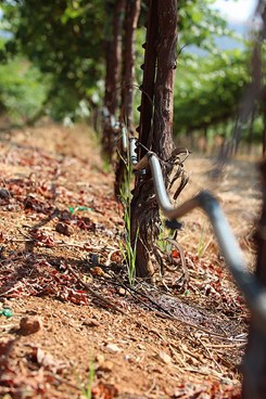
 ARS hydrologist Bill Kustas measures grapevine canopy width at a California vineyard to help evaluate satellite data used in models of vine water use. (Jessica Griffiths, D3883-1)
 -
 ARS scientists found a way to reduce poultry litter fertilizer use and maintain yields in Mississippi cotton and corn. (John P. Brooks, D3875-2)
They are projects with very different goals: helping to save water in California’s vineyards; reducing fertilizer runoff from cotton and corn fields in Mississippi; and cutting back on the use of a costly fungicide in Texas.
Yet such diverse efforts by Agricultural Research Service (ARS) scientists share a common objective: coming up with ways to save water and protect the environment by targeting fertilizer, irrigation water, or other treatments to the specific sections of vineyards, farms, or fields where they are needed.
The reason for this strategy—known as precision agriculture—is simple. In agricultural operations, the best approaches may vary from one section of a field to the next. That’s why one team of ARS scientists is helping a major wine producer develop tools for deciding when to irrigate sections of its vineyards and another group is showing cotton growers how to save thousands of dollars on costly fungicide treatments.
“The practice of targeting crop needs to specific areas isn’t new, but we’re developing better strategies and using them to produce some of our most important crops in more efficient and sustainable ways,” says Johnie Jenkins, director of the ARS Crop Science Research Laboratory at Mississippi State, Mississippi.
Saving Water in Wine Country
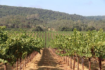 In California, some vineyards are spread over thousands of acres, with different soils and climate conditions. Satellite-driven models provide data for irrigation management over these widely varying conditions. (Jessica Griffiths, D3881-1) |
At the ARS Hydrology and Remote Sensing Laboratory in Beltsville, Maryland, William Kustas and Martha Anderson are fine-tuning computer models so that the E&J Gallo Winery, in California, will be better equipped to save water by determining how much water is needed in specific areas of their vineyards and exactly when it should be applied. The models tap into data collected by satellites that measure land surface temperature, which provides information about soil and vine moisture levels and rates of water use or “evapotranspiration” (ET).
The ARS model uses satellite measurements of land surface temperature in a unique way by separating out the vine canopy from the soil surface temperatures. This gives the model more precision and enables researchers to better evaluate vine stress, says Kustas, an ARS hydrologist. “If you have vineyards spread out over thousands of acres, you’re going to have different soils and climatic conditions, and the irrigation needs are going to be very different across that operation,” he says.
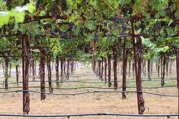
 Close-up of irrigation tubing in a vineyard. ARS-developed remote- sensing methods can schedule irrigation, which could reduce vineyard water use by 25 percent. (Jessica Griffiths, D3882-2) |
The project has been instrumental in helping Gallo, which hopes to eventually cut its water use by up to 25 percent, according to Nick Dokoozlian, a Gallo vice president and a former professor of viticulture and enology at the University of California-Davis.
“By improving how we target irrigation water, ARS scientists are helping us maintain the health of our vineyards, ensure the quality of our grapes and our wine, and helping to save groundwater for future generations,” Dokoozlian says. Gallo owns and operates 25,000 acres of vineyards in California and contracts with grape producers operating another 200,000 acres.
The techniques developed will be shared with other vineyard operators and potentially save water across more than a million acres of grape vineyards in California, where water supplies are critical. Because the models are designed to estimate ET in areas with elevated plant canopies cultivated in rows, California’s fruit orchard operators also may benefit from the efforts, Kustas says.
Project partners include researchers at Utah State University, who are developing unmanned aerial vehicles (commonly known as drones) capable of monitoring plant water use and stress in much finer resolution than imagery available from satellites. Another collaborator—Chris Hain at the National Aeronautics and Space Administration's Marshall Space Flight Center in Huntsville, Alabama—is working to extend mapping capabilities beyond California.
 A network of drip-irrigation tubing throughout a California vineyard. (Jessica Griffiths, D3882-1) |
Gallo and other winemakers want uniformity in the quality of their grapes, but that can be challenging when vineyards are spread out over so many types of soils and climates.
“That’s why this approach is well suited to Gallo’s vineyards and other growers interested in using precision agriculture. You can isolate areas that are under stress and need irrigation, as well as areas that are well irrigated,” says Anderson, a physical scientist.
Over the next 2 years, the researchers hope to develop a daily digital map of ET over California’s Central Valley, which includes some of the world’s most productive agricultural lands, at a resolution that will give growers a firm grasp of conditions in specific areas in their fields.
Reducing Runoff into Waterways
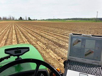 ARS scientists created a prescription map (shown on the monitor) of a field using a soil-mapping unit attached to a tractor. The map showed where best to apply poultry litter. (Chris Bellamy, D3876-1) |
At the ARS Genetics and Sustainable Agriculture Research Unit, at Mississippi State, Haile Tewolde and Ardeshir Adeli have found ways to help growers use prescription maps to apply only as much poultry litter as they need, and no more, to prevent runoff into waterways. “If you apply too little fertilizer, you run the risk of reducing yields, but if you apply too much, it ends up running off into streams and rivers. Yet farmers are applying the same amounts uniformly, even though the needs of a field, from one end to the other, might not be the same,” says Tewolde.
It takes about 3 to 5 tons of poultry litter per acre to fertilize cotton fields in Mississippi and about twice that amount to fertilize corn.
Organic matter in the soil enriches crops with nitrogen and other nutrients, but it washes downhill in rainstorms, so there is often less of it at higher elevations in a field. To make up for those differences, Tewolde and Adeli applied higher-than-average rates of litter in higher elevations—and lower rates in lower elevations—on a corn field and a cotton field for 5 years in north central Mississippi. Before applying the litter, they created prescription maps, using commercially available technologies that can be attached to a tractor, detailing the contours and the amounts of soil organic matter in specific 800-foot long strips of land.
|
|
Their preliminary results show that varying the litter application rate reduces the amount of poultry litter required in corn and cotton fields and nets higher yields for each ton of litter applied.
Some farmers have been mapping their soils for years to minimize their use of costly commercial fertilizers. But the results show that farmers would also benefit from targeting their use of poultry litter fertilizer.
“The goal for farmers when they adopt this strategy is not only for them to save money, but also to improve soil health in the long run, increase yields, and reduce the amount of nutrients washing into waterways,” Tewolde says.
Less Fungicide Residue in Soils and Waterways
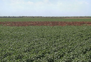 The brown section of this cotton field is infested with root rot. (Chenghai Yang, D3877-1) |
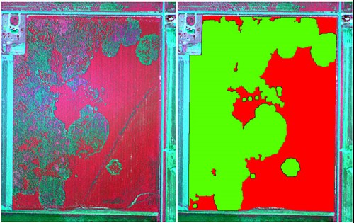
ARS researchers at the Aerial Application Technology Research Unit in College Station, Texas, have found a way for cotton growers to use aerial imagery and satellite data to target a fungicide to specific areas of their fields to control a serious cotton disease.
Cotton root rot is most severe in Texas, where it costs growers an estimated $29 million a year. It is also found in Oklahoma, Arizona, and New Mexico.
Many farmers apply flutriafol fungicide (Topguard Terra) to entire fields to control cotton root rot. But Chenghai Yang, an ARS agricultural engineer in College Station, and his colleagues have found that on average, only 20 to 40 percent of most Texas cotton fields are infested. The fungicide costs $50 an acre to apply, so being able to target the treatment to just half of a 100-acre field would save $2,500. Many cotton farms in Texas are over 500 acres.
“For many farmers, the savings year after year could be considerable,” Yang says.
Yang recently published an article for growers spelling out how they can use either publicly available aerial imagery or satellite data to create prescription maps that will identify infested areas within their fields. He notes that the disease occurs year after year in the same areas, so that aerial images that are even 10 years old will suffice—as long as the field was not treated in the year that the image was taken.
|
|
The variable-rate application systems for applying the fungicide can be used with most tractors and are available at many agricultural supply dealerships. Dealers and suppliers also can show famers how to create the prescription maps and how to add the variable rate systems to their tractors and applicators, Yang says.
“More and more farmers are picking up on this as word spreads about how it saves on costs. It also reduces the likelihood that fungicide residues will reach our soils and water,” Yang says.—By Dennis O’Brien, ARS Office of Communications.
Key Facts
- ARS computer models use satellite data to curb water use in vineyards.
- Soil mapping targets poultry litter applications, reducing nutrient runoff.
- Cotton growers can reduce fungicide use with satellite and aerial imagery.
Full Story