United States Department of Agriculture
AgResearch Magazine


Keeping Waters Clean, Nearby and Downstream
-
 At a Pennsylvania dairy research site, ARS scientists and Penn State collaborators collect ammonia samples and review plot layouts in an LTAR experiment. (Stephen Ausmus, D1856-11)
The Harpster brothers—Abe, Aaron, and Andy—own Evergreen Farms, one of the largest dairy operations in Pennsylvania: 2,700 milking cows on 6,500 acres along with fields of grass, corn, and alfalfa to feed them. Their other claim to fame is the farm’s pristine Spruce Creek, where presidents from Eisenhower to Carter and other notables including the owner of the Chicago Cubs and Grammy Award-winning singers have come to fish for rainbow trout.
Now the Harpster brothers have added to their stature by signing up Evergreen Farms to be a living laboratory for balancing farm productivity and protecting the environment in the Agricultural Research Service’s (ARS) Long-Term Agroecosystem Research (LTAR) network.
LTAR is a sophisticated framework ARS created in 2011; it includes 10 environmentally significant watersheds, among them the Upper Chesapeake Bay. The program is designed to collect and integrate years of data about how agricultural practices affect our landscapes, waterways, and air. This includes documenting the physical, chemical, and biological outcomes of different farm management options, like new crop rotations, adjusting grazing strategies, and changing irrigation patterns.
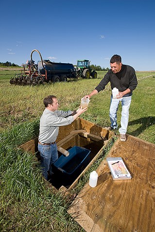 ARS scientists collect runoff samples as part of an LTAR experiment. (Stephen Ausmus, D1858-15) |
Making Research Personal
The Harpsters have always been committed to the sustainability of the land their grandfather bought in the 1930s and where their father started Evergreen Farms in the mid-1950s.
“We live here, drink the water here, and breathe the air here, and try to do the best for our people, our cows, and our land. We expect to pass this farm down through the generations of our families,” explains Andrew Harpster. “I may not be a scientist, but I’ve learned enough to know that everything is connected,” he adds. “If we don’t do it right, for example, the manure we spread on our corn fields can run off into Spruce Creek, damaging our trout habitat, and from there into the Juniata River, which flows into the Susquehanna and then 200 miles downstream into the Chesapeake Bay.”
But Harpster points out that he, like almost every dairy farmer he knows, also wants to be sure any changes he makes will actually make a difference to the Bay’s health, especially if those changes will affect his productivity or profitability.
“While we do get it, a lot of farmers are also thinking the Bay is more than 4 hours south of here, and along the way to it, there’s urban and suburban soil erosion, runoff from lawn fertilizers, waste from water treatment plants, and cars’ gas and diesel,” he says. “So am I really that much of the problem? We want facts, and we want the people setting regulations to do it based on facts.”
A Commitment to Facts
To help find those facts, the Harpsters are committing 200 acres to ARS’s LTAR project, and not just for a few years, but for the next 50 years. One hundred of those acres will continue on under the farm’s standard management routine, only with the addition of carbon dioxide monitoring towers; wind erosion gauges; sensors to check water, soil, and nutrient cycles; and even weather reporting stations—all to provide the data to form a “business-as-usual” baseline.
Measurements from these fields will be compared to similar measurements from the other 100 acres. “Those are the ones we call the ‘aspiration acres,’” says soil scientist Peter Kleinman in the ARS Pasture Systems and Watershed Management Research Unit in University Park, Pennsylvania. He leads the Upper Chesapeake Watershed LTAR project. “We’ll be offering the Harpsters a portfolio of management strategies they can adopt for these acres, each of which we think should have an environmental benefit and make for more sustainable agriculture while increasing profitability or at least without harming their bottom line.”
From that list, the Harpsters will choose what they believe they can work with best. Once the first results are analyzed, the LTAR team may reconsider the portfolio and suggest other options. Evergreen Farms is the first farm in the Upper Chesapeake Watershed to agree to be part of LTAR.
A Common Experiment
Aspirational versus business-as-usual scenarios make up a relatively new concept developed by LTAR scientists called the “common experiment.” For this type of study, at least one whole field represents the “real world,” and another field represents “the world as we hope it can be,” where productivity and sustainability are in harmony. “Then we take common measurements between the two,” says Kleinman.
The common-experiment system also recognizes that, in the midst of all the factors being measured with an eye towards improving sustainability, the farmer’s need for profitability must also be appreciated. This led Kleinman to add agricultural economists, social scientists, and engineers to his LTAR team.
“Our LTAR economists and sociologists have been helping us do a better job of connecting the dots for the farmers and explaining the science—for example, how to keep nutrients and sediment out of the water flow,” Kleinman says. “And knowledge sharing works both ways. Our lab scientists have learned a lot about the realities of farming for a living, everything from crop cycles to equipment brands to what it’s like to haul manure to a field.”
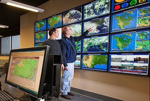 ARS scientists and collaborators developed “Fertilizer Forecaster,” an on-line tool to help farmers limit fertilizer runoff after a rain. The program uses forecasts from the National Weather Service. (Stephen Ausmus, D1859-17) |
Predicting the Future
Says Kleinman, “Most of our research is about quantifying how particular farm management practices are contributing to pollutant levels under what conditions so we can build watershed-level models to predict what will happen under future scenarios. But as we learn more, our models are becoming more scalable, to the point where we can simulate possible outcomes of changes in policies and regulations for an entire state, at least on the scientific side.”
LTAR was conceived to fill important scientific knowledge gaps, which includes building models that can result in tools for public policymakers, Kleinman points out.
“It didn’t take long before these sophisticated models were taken into account by organizations that make policies,” he says. “Many researchers from our lab serve as technical advisors to state and federal organizations, and ARS research has played an important role in guiding how the six Chesapeake Bay states work to clean up the Bay.”
One of the newest tools is a model called the “Fertilizer Forecaster,” developed by Kleinman, ARS hydrologist Tony Buda, and colleagues at Pennsylvania State University and the U.S. National Oceanic and Atmospheric Administration’s Middle Atlantic River Forecast Center. It was originally intended to help farmers make decisions about when and where to apply fertilizers and/or manure on fields to give them better control of incidental nutrient losses in run-off.
The Fertilizer Forecaster relies on state-of-the-art weather models to provide 1-, 2- and 3-day forecasts of runoff risk, based on the amount and intensity of rain expected. The tool also integrates zoom-in maps that identify areas in a farmer’s field that are most prone to runoff with the amount of rain forecast and the soil’s actual wetness.
“We already know from Kleinman’s research in the Catskill Mountains that if there are 9 days with no rain after a manure application, even on the most vulnerable soil, you will have half the phosphorus runoff than if the rain comes within 2 days of treatment,” Buda says.
When the tool becomes available to the public this fall, farmers will be able to check the runoff-risk rating for their region, and if it’s moderate or high, zoom in to their farm to view maps showing where runoff is expected to occur within individual fields.
Balancing Priorities
LTAR data can help provide policymakers with the big picture so it can be possible for productivity and sustainability to be synergistic goals rather than antagonistic ones. But there is a wide range of factors to take into account to balance priorities between agriculture and the environment. Once policies are set, the nuts and bolts of implementation and monitoring for adherence must be figured out. Decisions can be made on beliefs and desires, but science-informed policy is a lot more likely to actually result in cleaning up the Chesapeake Bay.
“Without good science that describes the real world and solid monitoring about how actions are working, policymakers and regulators might develop an overly optimistic understanding of how much pollution has been or could be prevented from reaching the Chesapeake Bay,” Kleinman says.
Still at its heart, LTAR is about taking measurements over years and decades, time enough for long-range effects to become clear and conclusions about best practices to be solidified, and then making the data accessible to anyone. The Upper Chesapeake LTAR team recently put its initial database online with long-term field information about land management practices, water quality, and related data for about 15 farms and nearly 300 fields within the Appalachian Ridge and Valley watershed. These datasets are a valuable resource for current and future scientific analyses, particularly when combined with others from across the nation.—By J. Kim Kaplan, ARS Office of Communications.
Key Facts
- The Chesapeake Bay Watershed is part of ARS’s LTAR network.
- The LTAR network has 10 environmentally significant watersheds.
- Scientists and farmers test strategies that may preserve water quality.
- ARS helped develop the “Fertilizer Forecaster” tool to reduce nutrients in run-off.
Full Story