ARS Validates Soil Moisture Data Collected Via Satellite
The European Space Agency’s Soil Moisture and Ocean Salinity (SMOS) mission includes the latest advance in using Earth-orbiting satellites for estimating soil moisture across the globe. The SMOS satellite was launched in 2009 and was designed to estimate soil moisture levels to within 4 percent, which is like measuring a teaspoon of water in a handful of dry soil.
To capture this data, SMOS uses a new sensor technology that is the first passive L-band system—measuring microwave radiation emitted around the frequency of 1.4 gigahertz—in routine operation. But the accuracy of the information collected by this new technology still needs to be verified with actual soil moisture measurements, a task perfectly suited for a team of Agricultural Research Service scientists.
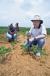
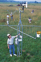
In 2002, ARS scientists established soil moisture monitoring networks in four of the agency’s long-term experimental watersheds to verify the accuracy of soil moisture data collected by other Earth-orbiting satellites. The researchers have been monitoring soil moisture levels in these networks—located in ARS watersheds at Walnut Gulch, Arizona; Little Washita, Oklahoma; Little River, Georgia; and Reynolds Creek, Idaho—hourly since 2002. So they had a vast amount of data from a range of environments they could use to validate SMOS soil moisture measurements.
The research team was led by ARS hydrologist Tom Jackson of the Hydrology and Remote Sensing Laboratory in Beltsville, Maryland. The team compared a year’s worth of soil moisture data collected by SMOS with data from the four ARS watersheds and from another satellite system.
|
|
The researchers determined that the SMOS soil moisture estimates approached a 95-percent rate of accuracy, and they also identified conditions that reduced accuracy. For instance, SMOS records measurements in the early morning as the satellite ascends over the horizon and in the late afternoon as the satellite is descending. Rain showers generated from heat and moisture that had accumulated in the atmosphere throughout the day would often saturate the upper soil levels in the afternoon. These strong downpours would result in an overestimation of soil moisture by the SMOS sensors. Jackson’s team devised a method for flagging and adjusting the data to improve the accuracy of the resulting soil moisture estimates.
Other ARS researchers contributing to this project include Michael Cosh, from the Beltsville lab; Patrick Starks, at the Grazinglands Research Laboratory in El Reno, Oklahoma; David Bosch, at the Southeast Watershed Research Laboratory in Tifton, Georgia; Mark Seyfried, at the Northwest Watershed Research Center in Boise, Idaho; and Susan Moran and David Goodrich, both from the Southwest Watershed Research Center in Tucson, Arizona.
The scientists published their findings in 2012 in IEEE Transactions on Geoscience and Remote Sensing.—By Ann Perry, Agricultural Research Service Information Staff.
This research is part of Water Availability and Watershed Management, an ARS national program (#211) described at www.nps.ars.usda.gov.
To reach scientists in this story, contact Ann Perry, USDA-ARS Information Staff, 5601 Sunnyside Ave., Beltsville, MD 20705-5128; (301) 504-1628.
"ARS Validates Soil Moisture Data Collected Via Satellite" was published in the August 2013 issue of Agricultural Research magazine.


