United States Department of Agriculture
AgResearch Magazine


Long-Standing Erosion Calculator Enters 21st Century
|
|
Seth Dabney is busy tweaking a soon-to-be-unveiled update of the Revised Universal Soil Loss Equation, Version 2 (RUSLE2), which moves the original equation ever further from its origins in the age of slide rules to the era of computing.
Dabney is research leader of the Watershed Physical Processes Research Unit, at the Agricultural Research Service’s National Sedimentation Laboratory in Oxford, Mississippi.
RUSLE2 has retained the integrity of the original Universal Soil Loss Equation (USLE)—in greatly expanded form—and integrated an updated database with a computer model that reflects both the latest in computer technology and scientific discoveries about erosion processes. It is unlikely that there is a more powerful, proven, practical computer model than RUSLE2. Its ability to predict daily erosion related to any human activity anywhere in the nation, based on a host of conditions, through a combination of simulation model, vast database, and scientific knowledge, makes it an excellent example of computational science and technology.
But RUSLE2 remains first and last what it was always designed to be: a management tool that allows conservationists to make better management decisions.
This state-of-the-art technology traces its heritage to the paper-and-pencil version of USLE, which has been the standard way to estimate soil erosion on farms for more than four decades. It was first developed in the late 1950s, before calculators, let alone computers. In fact, at one point the equation came with plastic slide rules custom made for it. The USLE is now recognized as one of the most significant developments in soil and water conservation history, worldwide.
|
|
Standing the Test of Time
The USLE began as a fairly simple equation that gave its answer in tons of soil lost per acre per year by multiplying five factors, with the numbers for each factor derived from paper tables of figures for different parts of the country and different soils. Proof of the worth of USLE’s humble pencil-and-paper calculation is that it is still embedded as the heart—and anchor—of the new, sophisticated model that houses it, although the tables of factors no longer exist.
Its core function is to estimate soil eroded by the impact of raindrops and by the flow of runoff water across land disturbed by plowing and tilling. But functions have been added over the years, such as estimating how much plant residue can be removed from crop and pasture lands for ethanol production without exposing the soil to excessive erosion.
And the equation continues to add capabilities. It is now used to estimate erosion wherever land is disturbed, whether by farming or ranching, pasture replanting, or nonfarm activities such as construction, mining, or clearcutting and road building in forests.
Since the USLE moved into widespread use in the 1960s and 1970s, every conservation plan written for farmers, ranchers, and others by the USDA Natural Resources Conservation Service (NRCS) has been based on soil-erosion calculations derived from this equation. It is used by all 3,000 NRCS field offices as well as the agency’s state and area offices.
Ken Renard, a hydraulic engineer who came to ARS in 1957 and has been a leader in the development of the USLE and RUSLE even in retirement, says that as “research made a lot of progress in more realistically describing erosion from farming operations,” the need to update USLE technology became clear.
The result was RUSLE1, which started moving into use in 1992; it was the first wholesale reworking of the erosion-predicting technique using digital computer technology.
|
|
The Improvements Continue
Spearheaded by now-retired ARS agricultural engineer George Foster, RUSLE2 is actually a combination of observation- and process-based science, incorporating its original roots in collected field data with the latest in computer models that can simulate processes such as erosion, says Giulio Ferruzzi, a conservation agronomist at the NRCS West National Technology Support Center in Portland, Oregon. Ferruzzi forwards all of the agency’s requests for changes to the RUSLE2 to Dabney and Daniel Yoder, a professor at the University of Tennessee at Knoxville.
At the time RUSLE1 moved into use, the task of improving its computer programs fell to Yoder, who, while a graduate student, worked for ARS as an agricultural engineer at the National Soil Erosion Laboratory in West Lafayette, Indiana, at Purdue University, the birthplace of the equation.
Now, 20 years later, Yoder is still improving the RUSLE2 version, first developed in 2001. RUSLE2 brought the equation into the 21st century, making it a much more powerful tool, yet much more user-friendly, with graphics, including icons for things like bulldozers and tractors.
Yoder says, “I take Dabney’s science ideas and translate them into computer code. But the process is give-and-take between me, Dabney and his ARS colleagues, and NRCS.” He says their recent work on improvements to RUSLE2 involved better prediction of crop residue.
Ferruzzi adds that Dabney for the first time made it possible for NRCS to help ranchers more accurately learn the effects of cattle grazing on erosion. The update about to be unveiled simulates the natural life and death of pasture plants as well as the effects of the different eating habits of grazing animals. Ferruzzi explains that when cows are let into a pasture for a short time, they tend to eat everything in sight by “mob grazing.” But when cows are put in a pasture for a season, they have time to be more selective, eating only the freshest growth. The model Dabney is working on takes that into account.
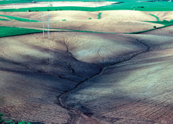
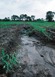
A New Way To View Erosion: But Ephemeral Gullies Still Elude
Dabney also added a way to model the erosive flow of water on an entire hill slope as one block, from top to bottom, missing—for now—only the topographic swales where water runs intermittently when it rains heavily and forms ephemeral gullies. The current version also predicts where the eroded soil will collect after it leaves the hillside, something particularly important to construction planners.
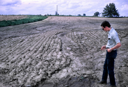
Renard says that ephemeral gullies often cause the most erosion on farms. They’re particularly insidious because they are obliterated by tillage, but reappear during a wet spell the next season. Renard says that although RUSLE2 is still missing these gullies, Dabney is moving in the direction of solving that.
Ferruzzi says NRCS can use this new modeling technique to pinpoint where permanent gullies might form and suggest grassed waterways or other conservation measures there to prevent gully formation.
A Crown Jewel
Yoder calls the extensive NRCS database a “crown jewel of RUSLE2.” Federally supported data collection began with 10 experiment stations in 1929, located strategically to represent as many crops and climate and management conditions as possible. NRCS has since built it up to include every state in the nation plus the territory of Puerto Rico and the Pacific protectorates.
Dabney agrees, saying that the NRCS database is exhaustive, with 30,000 combinations of vegetation, farming and ranching operations, and residue types. “NRCS developed this database at regional centers in Nebraska, Oregon, South Carolina, and Texas, and it has been in use for 10 years now,” Dabney says. NRCS has also developed maps for RUSLE2 that divide the country into crop management zones. The maps disregard political boundaries, instead delineating zones based on common crops and management practices.
Dabney says that it is this very database that keeps RUSLE2 from coming untethered from reality, as pure process models do when they operate outside of known territory. RUSLE2 can operate accurately anywhere in the United States—and probably the world—because it is grounded by the vast database collected from field measurements.
Dave Lightle, former NRCS national database manager for RUSLE2, worked for 10 years to produce the database, with the different combinations of management scenarios broken down by the crop management zones. The scenarios replace USLE’s key crop management factor. “RUSLE2 now creates these scenarios. It goes way beyond USLE and RUSLE1,” says Lightle, who continues to work part-time on RUSLE2 in retirement. Linda Scheffe, at the NRCS National Soil Survey Center in Lincoln, Nebraska, is the current RUSLE2 database manager.
The database contains 20 key soil properties that affect soil erosion for all soils in the United States. It also contains the climate for all counties, the precipitation ranges across the country, and hundreds of tillage options. RUSLE2 provides daily information, unlike USLE, which provided information on a yearly basis.
Lightle says that this database is the most sought-after feature of RUSLE and is being used in other models. Currently, users have to download soil data from the NRCS National Soil Information System, the agency’s official soil database. But Lightle says that in the near future RUSLE2 will be live on the Internet, enabling access to that data without downloading.—By Don Comis, formerly with ARS.
This research is part of Climate Change, Soils, and Emissions (#212) and Water Availability and Watershed Management (#211), two ARS national programs described at www.nps.ars.usda.gov.
To reach scientists mentioned in this story, contact Robert Sowers, USDA-ARS Information Staff, 5601 Sunnyside Ave., Beltsville, MD 20705-5129; (301) 504-1651.
"Long-Standing Erosion Calculator Enters 21st Century" was published in the April 2012 issue of Agricultural Research magazine.