United States Department of Agriculture
AgResearch Magazine


Agro/Environmental Data at Your Fingertips
|
|
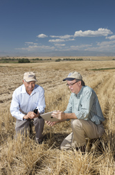
A farmer and a conservationist examine a gully in a field and wonder how it formed, how much erosion it causes, and what they can do to repair it. The conservationist picks up a mobile phone for answers. The phone’s GPS (Global Positioning System) locates the gully’s coordinates and connects to a computer model service that calculates soil erosion under various agricultural management practices. The answers return quickly, borrowing the power of a large, remote, Internet-based data center.
That scenario will be real in the not too distant future, since the framework for making the science available, the Object Modeling System (OMS), is operational and available worldwide to anyone at oms.javaforge.com, and work has begun to design applications that connect to the model services.
“OMS is a computer framework to easily create and update problem- or region-specific compatible models, using science modules chosen from a library. It provides a uniform system of evaluation and delivery of models to users,” says Laj Ahuja, research leader at the Agricultural Systems Research Unit in Fort Collins, Colorado. OMS was created by ARS in partnership with the USDA Natural Resources Conservation Service (NRCS), Colorado State University (CSU), U.S. Geological Survey, and other collaborators.
The current primary ARS application of OMS is to deliver science model services to NRCS in support of its Conservation Delivery Streamlining Initiative, thus improving technical assistance to farmers and ranchers.
Olaf David, OMS architect and computer scientist with CSU at Fort Collins, explains that OMS will house many agro-environmental modules and models. He says modelers from around the world can collaboratively develop and contribute to models in OMS. “Modelers from Europe are already doing that,” David says. “Although ARS and other organizations developed the framework, it is also part of the global modeling community.”
ARS and CSU modelers are using OMS to support USDA programs. “The Precipitation and Runoff Modeling System has been incorporated into the NRCS water supply forecasting this year, and the new AgES-W conservation assessment model is undergoing validation,” says Frank Geter, team leader with the NRCS Information Technology Center at Fort Collins.
Says Jack Carlson, retired NRCS chief information officer and project collaborator, “Software that accesses science models in OMS will help conservationists devote more of their time to their primary mission, providing science-based conservation planning and technical assistance to farmers.”
“Every workday, conservationists service more than 5,000 conservation plans. In the past, running models has been a laborious process. OMS has been designed to improve efficiency by 80 to 90 percent,” Carlson says.
Just as millions of people do daily with online maps, field conservationists will zoom to their area of interest on their smart phones or wireless laptops. Data embedded in resource maps for the area will be relayed to OMS-hosted model services to compute answers leading to recommendations for the resource problems the farmer has identified.
“Computer models, managed in frameworks like OMS, coupled with field experiments and wireless delivery devices are the next frontier for agricultural research and technology transfer,” says Ahuja. “These frameworks harness the growing power of computer technology, enabling it to reach its full potential.”—By Don Comis, Agricultural Research Service Information Staff.
This research is part of Water Availability and Watershed Management (#211), an ARS national program described at www.nps.ars.usda.gov.
To reach scientists mentioned in this story, contact Don Comis, USDA-ARS Information Staff, 5601 Sunnyside Ave., Beltsville, MD 20705-5129; (301) 504-1625.
"Agro/Environmental Data at Your Fingertips" was published in the February 2011 issue of Agricultural Research magazine.