United States Department of Agriculture
AgResearch Magazine


The Ogallala
Gauging, Protecting the Aquifer’s Health
|
|
When Nolan Clark started with ARS 37 years ago, people predicted there would be no more water in the Ogallala Aquifer by the year 2000. “We’ve proven that wrong—since we’re not out of water,” says Clark. “But we need to develop new science and technology to make sure we can say that again in 2050. We’re now in a worldwide water crisis, not just local crises.”
Clark, an agricultural engineer, is director of the ARS Conservation and Production Research Laboratory in Bushland, Texas, and now oversees the Ogallala Aquifer Program, an ARS-state university consortium focused on large-scale regional problems and their research solutions. (See “Forum” in this issue.)
Dan Upchurch, director of ARS’s Southern Plains Area, agrees that “water is the most important issue facing farmers worldwide. The Ogallala Aquifer Program began in 2004, when I was director of the ARS Cropping Systems Research Laboratory in Lubbock, Texas, and my involvement continues,” Upchurch says. “It fits the mission of the Lubbock and Bushland labs perfectly, and it brings in university expertise in groundwater hydrology and economic analyses. We pool our resources, including colleagues skilled in agricultural education, communications, irrigation technologies, water management, crop genetics, cropping systems, and concentrated animal feeding operations.”
The crisis of groundwater decline for the Ogallala region has been exacerbated by the rising cost of energy needed to pump water from the aquifer. In many wells and regions, the available water may be too deep to be pumped economically. Even in areas where the pumping depth is economical, geology limits pumping rates as the water table declines.
|
|
Turning Taps On and Off Is Key
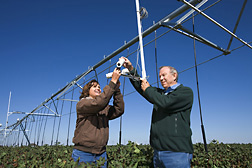
One promising new technology that ARS scientists are counting on to conserve Ogallala water is automating irrigation systems to precisely apply water only when needed, as determined by plant leaf temperatures.
Susan O’Shaughnessy, an agricultural engineer in ARS’s Soil and Water Management Research Unit at Bushland, is making the time-temperature threshold (TTT) system wireless, so it can be commercialized. Steven Evett, a soil scientist there, advanced the TTT concept based on previous research from the ARS laboratory in Lubbock showing that each crop species is biologically programmed to grow best at certain temperatures—a narrow temperature window that varies from crop to crop.
Until recently, TTT was suitable only as a research tool because of the long strands of wires needed to connect field infrared thermometers and those mounted on irrigation center pivot arms to computers.
Now, O’Shaughnessy has 16 wireless infrared thermometer sensors mounted on the arm of a center pivot system that irrigated cotton this past season. She and colleagues developed the circuitry necessary to link the thermal sensors to commercially purchased wireless modules. Next, she will test improved wireless modules that will prevent data transmission interference.
“In our area, for cotton, we use a temperature threshold of 82˚F and a time threshold of 7½ hours,” O’Shaughnessy says. “This means that if the cotton leaf temperature stays above 82˚F for more than 7½ hours, irrigation will be automatically started.”
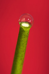
O’Shaughnessy is studying cotton because it’s a common crop in the southern Ogallala region. It needs less water than grain crops like corn, so it is more suited to an area like the Texas High Plains, where water supplies and rainfall are limited.
O’Shaughnessy is also testing photo diode sensors that, by detecting reflected light, can help determine whether plants are stressed by lack of water or disease. They can also distinguish bare areas where no plants are growing. Eventually the photo diode sensors will be mounted alongside the thermal sensors on the center pivots.
Soon O’Shaughnessy will expand the number of network sensors for another season’s tests. Ultimately, she and Evett will commercialize the system through a cooperative research and development agreement with a center pivot manufacturing company that can build the sensors into their equipment. Farmers use center pivots on 75 percent of the area’s irrigated acres. They use the more expensive drip irrigation on about 5 percent of the irrigated land.
|
|
Designing the Best Ways to Irrigate
“But the number of drip irrigation acres is growing as research points to its possible advantages in conserving Ogallala water,” says Paul Colaizzi, an agricultural engineer at Bushland. Colaizzi is working with Freddie Lamm, an agricultural engineer at Kansas State University’s Northwest Research-Extension Center at Colby, Kansas, to find the best irrigation systems and designs for each major crop in their locations.
Colaizzi and Lamm are comparing subsurface drip irrigation (SDI)—buried irrigation lines—to two different center pivot overhead spray systems.
He and Lamm have reviewed about a decade’s worth of data from experiments at Bushland; Halfway, Texas; and Colby. They found that, with deficit irrigation, sorghum yields with SDI were slightly higher than with center pivot, while with full irrigation, sorghum yields were slightly lower with SDI. Deficit irrigation uses less than optimal rates of irrigation water.
Colaizzi thinks the higher yield with SDI is “because it virtually eliminates soil-surface water evaporation and directs more of the water to the plant. But fully irrigating a field with drip irrigation might be giving the plant too much water, slightly decreasing yields,” Colaizzi says. “The water may be concentrating around the plant roots and blocking aeration and also draining plant nutrients too far down for plant roots to reach.”
|
|
Colaizzi and Lamm are experimenting with all design features of subsurface drip irrigation, from how far the lines are spaced to how deep they are placed and where they are placed in relation to the seedbed.
Jim Bordovsky, an agricultural engineer with Texas AgriLife Research (formerly the Texas Agricultural Experiment Station), supplied Colaizzi and Lamm with 5 years of data from an experiment with drip-irrigated cotton at Halfway. Bordovsky’s experiment showed that the costs of switching to drip irrigation could be greatly reduced by relaxing design standards without affecting yields in any meaningful way. He tested three designs, from the strict standards of current recommendations to one with “greatly relaxed” standards. All got about the same yields.
Their goal is to use less total water and still produce good yields. “We want to use the water more efficiently, but not just to spread it over more land. We want to actually lower the total amount of water pumped out of the aquifer,” Colaizzi says.
|
|
Measuring Input and Output
ARS agricultural engineer Prasanna Gowda, also at Bushland, is determining the Ogallala’s recharge rate. Clark says, “We already know the amount of rainfall we get, so if we learn the evapotranspiration (ET) rate for each crop, then we can calculate the actual recharge rate of the aquifer in various parts of the Great Plains states.”
ET is the total amount of water evaporated from plant leaves, including water taken in through plant roots, and water evaporated from soil.
“Dr. Gowda’s work is really important,” says Clark. “Policymakers need to know the recharge rate so they can determine how much water can be safely pumped over the next 50 to 100 years. We can be pretty sure it’s not a high rate here, because the aquifer has not refilled or even maintained its level of water.”
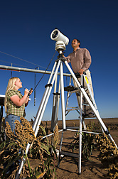
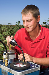
Gowda uses a scintillometer that employs laser light to measure the amount of turbulence caused by heat waves over crops. These are the wavy currents of air you see on hot days, especially over paved areas, but they also occur over plants and warm soil. These turbulent heat waves are a function of temperature and humidity fluctuations in the air. They’re also a measure of heat changes that help determine how much water the crops are using. The more turbulent the heat waves, the higher the water use.
Once Gowda gets the scintillometer calibrated, he can use it to estimate the ET rate of any field, just by shooting laser light across the field to a target. He’s also looking at ET on the regional scale, using scintillometers to read over great distances. His plan is to calibrate the scintillometers with weighing lysimeters at Bushland and then install scintillometers at other sites over the Texas High Plains for ground-level estimates of plant ET, for comparison with satellite sensors that take regional readings.
|
|
Conservation Via E-Mail
ARS engineers want to eventually give farmers daily ET rates via the Internet, using a combination of scintillometers, satellite sensors, and remote-sensing computer models.
Internet messages would be incorporated into bulletins currently issued daily via the Texas High Plains Evapotranspiration Network. The growing network has sites across the Southern and Northern High Plains of Texas to collect weather data to help farmers, urban landscapers, and others know more precisely the water-use amounts and rates for crops in the region. This network uses field weather stations and ARS crop water-use data to automatically send notices by fax and computer to advise when to turn their irrigation on and off.
Terry A. Howell, research leader of the Soil and Water Management Research Unit, says his unit’s work will lead to adjustments in network recommendations, to account for regional differences in ET for each major crop. Howell is a member of the team that is building this network, which includes Texas state universities; Texas AgriLife Research at Amarillo, Lubbock, and Uvalde, Texas; and Texas AgriLife Extension.
|
|
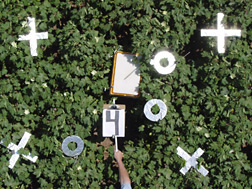
At Lubbock, about 100 miles south of Bushland, ARS plant physiologist Dennis Gitz is studying the recharge of the Ogallala Aquifer from playa lakes. He has found that water moves continually, if very slowly, below these ephemeral lakes that form when water drains into natural depressions lined with clay soils. This water flows from the bottom of the lakes slowly into the Ogallala, contributing to its recharge.
About 22,000 to 40,000 playa lakes dot the Southern High Plains, which includes the Texas Panhandle and part of neighboring New Mexico. They vary in size from 10 to 100 acres, with most around 10 to 30 acres.
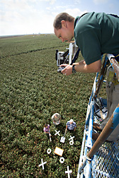
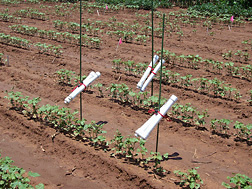
In related work, Gitz uses soil thermometers to see whether rainwater is seeping past the crop root zone. “Once the water gets below the reach of plant roots, it can only go down until it hits groundwater,” he says. The thermometers detect the sudden change in temperature that occurs at the point where rainwater stops seeping. Soil becomes either warmer or cooler, depending on conditions.
With colleagues from Texas Tech University, Gitz proved the thermometer idea works in a study that showed a good agreement between thermometer readings and actual water-infiltration readings. Soil thermometers are a much less expensive way to determine the reach of rainwater.
The scientists see the temperature gauges as an important tool for measuring the recharge rate of the Ogallala Aquifer from playas and perhaps other sources.
|
|
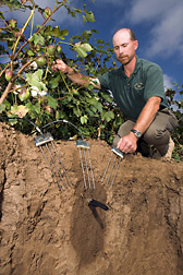
Gitz has installed a bank of instruments at 14 playas and is developing instruments for 16 more. These include instruments for weather stations, as well as for measuring water levels. Data from these instruments will be used to calculate expected water evaporation rates and then compare them to actual water losses. The difference between total water loss and evaporative water loss gives the loss from soil infiltration.
The recharge rate for the Ogallala Aquifer is considered negligible in cropped areas, where rainfall usually reaches only 2 to 3 feet below the ground surface and crop root zones extend deeper—to about 6 feet in the case of corn. “But we want to see if this holds true for playas—or whether some or all of these lakes have higher recharge rates than nonplaya areas,” says Gitz.
“If the recharge rate turns out to be negligible for playas in general, then we would forget about them as a source of recharge for the Ogallala. Then farmers could think about managing them sustainably for rangeland, hunting, fishing, and other recreational uses.”
“But if the playa recharge proves significant,” he says, “we would think about designing vegetative buffer zones around them to prevent pollutants from entering the lakes and seeping down to the Ogallala. In that case, we might use gamagrass or switchgrass just around the playas.”
BIOTIC, a SMART Way To Budget
ARS plant physiologist James Mahan, also at Lubbock, is one of the original theorists of the preferred temperature ranges of plants and using them as the basis for knowing when to irrigate. He and colleagues packaged a system called “BIOTIC” that was recently licensed to the company SMART CROP for commercial production.
Mahan sees BIOTIC helping the world deal with the new reality of water-deficit management. “Water has become the major cost in farming the Ogallala region,” he says.
Jeff Johnson, an economist at Texas Tech, and colleagues at Kansas State University, West Texas A&M University, and Texas AgriLife Extension—all involved in the Ogallala Aquifer Program—have done a modeling simulation to see what would happen to the southern part of the aquifer over the next 60 years under various scenarios. Using 91 counties for the simulation, they found that with no policy changes, the average saturated thickness of the aquifer in its southern part would decline by almost half. Most farmers would stop irrigating, and income per acre would drop by nearly half.
In a smaller follow-up study, Johnson and colleagues found that switching from irrigating to livestock grazing could change the economics more favorably, since growing pasture for grazing was more profitable than growing other nonirrigated crops.
The Texas Tech University scientists plan to continue using the models developed in their study to evaluate the consequences, county by county, of implementing various policy changes—such as taking land out of irrigation, at least temporarily.
“We will include scenarios in which incentives are also offered for water-conservation practices and planting water-conserving crop varieties, including those developed through biotechnology,” Johnson says.
Since 1980, most models have accurately predicted the decline of the aquifer, Johnson says, “though the models we use today are more accurate.”

A Little Water Can Go a Long Way
“Big Spring, another 100 miles south of Lubbock, has very limited well capacity, so we figured this would be a good place to test ways to make better use of the rain,” says Scott Van Pelt. A soil scientist in the ARS Wind Erosion and Water Conservation Research Unit there, he’s found that applying small amounts of irrigation water most of the year can increase cotton yields.
“We apply as little as a quart per minute per acre with SDI. Since there are no growing plants to use the water between the fall harvest and late spring planting, the irrigations replenish the supply of soil water for planting,” says Van Pelt. “The full profile of soil water at the beginning of the season, coupled with small deliveries of water through the SDI system, keep the young cotton plants relatively free of stress through a critical growth stage. This makes viable crop yields much less dependent on timely rains early in the season.”
Learning to wisely use and manage water is the only option for sustaining the rural economy of the Ogallala Aquifer region, one that is vital to the U.S. economy and its food supply.—By Don Comis, Agricultural Research Service Information Staff.
This research is part of Water Availability and Watershed Management, an ARS national program (#211) described on the World Wide Web at www.nps.ars.usda.gov.
To reach scientists mentioned in this article, contact Don Comis, USDA-ARS Information Staff, 5601 Sunnyside Ave., Beltsville, MD 20705-5129; phone (301) 504-1625, fax (301) 504-1486.
"The Ogallala: Gauging, Protecting the Aquifer’s Health" was published in the April 2008 issue of Agricultural Research magazine.