United States Department of Agriculture
AgResearch Magazine


Natural Environmental Protection Agents
|
|
A stretch of forest along a quiet stream or creek can make for pleasing scenery, especially during the fall, as the trees' leaves blaze a fiery orange. But there is more at work here than just natural beauty. These forest buffers protect the stream water by removing pollutants in farm runoff.
Historically, farmers have cleared these riparian areas to make more room for growing crops. Urban sprawl has also claimed its share, compromising water quality in the process. According to a U.S. Environmental Protection Agency survey released last year, pollution is a serious problem in 21 percent of the nation's 2000 or so watersheds. Agriculture's part in this is substantial.
But now, a new trend in farming is taking root. It calls for restoring the land closest to streams, rivers, and other vulnerable waterways with plantings of native vegetation. It's a form of environmental stewardship farmers are embracing. For these natural buffers protect stream water by capturing much of the sediment, nitrogen, phosphorus, and other agricultural chemicals borne in runoff or groundwater.
Installing Buffers
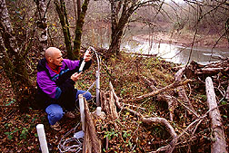
Ecologist Richard Lowrance of USDA's Agricultural Research Service has been studying these riparian buffer zones for over 20 years and is a firm believer in their importance to ensuring safe, clean water.
"The challenge now is to re-establish buffers where they no longer exist and to maintain the ones we do have," says Lowrance, who is based at ARS' Southeast Watershed Research Laboratory in Tifton, Georgia. A similar philosophy is behind the National Conservation Buffer Initiative program, which USDA's Natural Resources Conservation Service (NRCS) established in 1997.
|
|
Lowrance and other ARS researchers studying riparian zones work on or near heavily farmed watersheds. This places them in the heart of the action, helping farmers adapt buffer conservation strategies to their regions' specific soils, climate, topography, and hydrological patterns.
In Mississippi, for example, springtime rains can cause runoff so powerful that it carves deep gullies in valuable farmland—deep enough for a grown man to stand in. Erosion pulls valuable topsoil off the land, dragging it into lakes and streams where it becomes a pollutant. If farmers want government aid, they must develop a conservation plan to address the problem.
For the past 50 years, farmers have used grass waterways—which look like waterlines during a heavy rainstorm but otherwise appear to be just patches of tall grass. Water always seeks the land's lowest level, and these pathways protect the soil and slow the flow down just enough to prevent a gully.
In 1993, the NRCS invited eight states to evaluate grass hedges as an alternative form of erosion control, based on that agency's interim national standards. Hedges are dense patches of thick-stemmed grasses that stand strong against the deluge, trapping sediment. Last year Mississippi became the first state to adopt grass hedges as an approved erosion control technique.
Unlike the waterways, hedges slow runoff like water running through a fine-mesh sieve. They are arranged in narrow strips, like ladder steps. They don't follow a pathway straight down. Soil accumulates just above the strips and erodes slightly just below them.
"One good thing about grass hedges is farmers can work around them," says ARS agronomist Seth M. Dabney. "If they're tilling, all they have to do is drive the tractor between the hedges. But grass waterways can be damaged by tillage, so farmers should raise their tractors' equipment before going over them."
Dabney, who works at ARS' National Sedimentation Laboratory in Oxford, Mississippi, tested various thick-stemmed grasses as hedge makers. He found that two native American grasses, switchgrass and eastern gamagrass, were the top performers.
|
|
"Switchgrass and gamagrass are both native plants," says Dabney. "They're not going to upset the natural ecosystem balance or become an invasive weed."
Dabney says the plants could also be used to stem erosion on road and building construction sites. Because they are attractive plants, he adds, they could be left behind as part of the landscaping.
Vetiver, an Asian grass, has potential for erosion control in the southernmost part of the United States, such as south Texas and Florida, and for some U.S. territories.
Grass Hedges—Plus
Hedges are more effective when used with other soil conservation methods.
Dabney's colleague, agricultural engineer Keith C. McGregor, found that hedges reduced runoff in conventionally tilled soils. The most effective plan, however, was using no-till methods and hedges together. A no-till crop without hedges, but with a winter wheat crop, came in a close second.
All of these conservation methods helped lessen runoff. Worst by far was using conventional tillage alone.
"The thing we need to do now is test grass hedges to find out their maximum potential and their limitations," says McGregor. "Everyone agrees they slow erosion down, but we need to be sure about what they can and can't do."
"Tilling, which is basically just stirring the soil, is great for weed control, so you don't need as much pesticide," says Dabney.
"Many farmers won't or can't give it up. The good news from this study is that if they feel they must till, they can be confident that planting grass hedges will help reduce erosion."
The Grass Is Just as Green in Nebraska
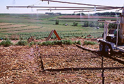
John E. Gilley, an agricultural engineer in the ARS Soil and Water Conservation Research Unit at Lincoln, Nebraska, also conducts research on grass hedges. His colleague, researcher Larry A. Kramer, works at ARS' National Soil Tilth Laboratory in Ames, Iowa. Their studies measured sediment loss on cropland farmed under two different tillage systems: minimum tillage and no-till.
Using a rainfall simulator, they first measured sediment loss on bare cropland that had been planted with corn the previous few years. They compared the amount of soil loss from this field to that from fields with grass hedges 2 feet wide and about 6 inches high.
|
|
"The narrow grass hedges reduced sediment delivery by 45 percent on the no-till treatments and 75 percent on the tilled plots," says Gilley. "This means a substantial amount of sediment is being trapped by the hedges along the hillslope that would otherwise have been transported down."
The ARS scientists say the narrow grass hedges also are a cost-effective alternative to more expensive technologies, such as terraces. Terraces cost about $330 per acre to install; grass hedges cost about $30 per acre.
The Buffer's Unsung Heroes
Helping farmers protect stream water using grass buffers also is a major goal of soil scientist Ron R. Schnabel at ARS' Pasture Systems and Watershed Management Research Laboratory in University Park, Pennsylvania.
Of particular interest to Schnabel is what happens beneath the soil—especially among the roots of grass and forest buffers. There, soil-dwelling bacteria consume nitrate and other nutrients from excess fertilizer and manure that has leached into shallow groundwater.
Nitrate leaching is of special concern in Pennsylvania, says Schnabel, because of the state's prominence in the Chesapeake region and the highly porous layers of lime, shale, and sandstone bedrock beneath the soil surface.
For their part, the bacteria help protect stream water by converting the soil's store of nitrate into atmospheric nitrogen, a process called denitrification. In low-lying farm areas, denitrification processes within a buffer can help remove up to 50 percent of the nitrate, says Schnabel.
But these helpful bacteria require more than nitrate alone. They need energy stored in organic carbon in the form of sugars, amino acids, and other things that seep from plant roots or decomposing material in the soil. Oxygen must also be scarce.
Without these conditions, the bacteria may not proliferate, and the buffers lose their ability to control nitrate losses.
Another of Schnabel's goals is to identify species of cool- and warm-season grasses that will foster a thriving microbial community. He's now conducting studies to that end at six experimental sites in Pennsylvania, New York, and New Jersey in cooperation with NRCS scientists.
"We're looking at the soil organic matter under warm-season grasses, cool-season grasses, and wooded areas," says Schnabel. "One question we want to answer is: Do any of these vegetation types offer an advantage in fostering denitrification?"
With a grass buffer, he adds, "farmers also have the option of harvesting it as feed."
On another front, the ARS lab is teaming up with NRCS and Pennsylvania State University scientists to map watershed hot spots. These include areas where nutrients like phosphorus can most easily wash from crop fields or pasture into stream systems and rivers like the Susquehanna.
"Phosphorus loss to streams is primarily a surface runoff phenomenon," notes Andy Sharpley, ARS' principal scientist on the project. "We're trying to identify regions in watersheds where riparian buffers are most likely to have an impact on nutrient losses to streams."
The Susquehanna is of particular interest because it eventually feeds into the Chesapeake Bay. If nutrients go unchecked, the Susquehanna—more than any other river in Pennsylvania—is likely to pollute the bay's delicate ecosystem.
"That makes people take notice," says Sharpley.
Of Farms and Pfiesteria
|
|
Most recently, that fragility came to public and scientific attention with outbreaks of Pfiesteria piscicida, or Pfiesterialike organisms, in several tributaries of the Chesapeake along Maryland's Eastern Shore. Biologists are now taking a close look at the role of runoff from crop fields on the peninsula, where nutrient-rich chicken manure is used as fertilizer.
A dinoflagellate with many different forms, Pfiesteria in its most aggressive state produces toxins that kill fish. It is the culprit behind fish kills in waterways of Maryland, Virginia, North Carolina, and other Atlantic seaboard states.
For better or worse, last summer's outbreaks on the Eastern Shore lent urgency to a new, $200 million, State Enhancement Program by the USDA and the state of Maryland. Announced in October, the 15-year program calls for the establishment of buffers along 5,000 miles of streams and other sensitive waterways in Maryland by the year 2002.
Whether in the form of grass hedges, filter strips, or forest buffers, Lowrance agrees that "if we're going to improve water quality in agricultural areas, we'll have to start at the streams and work our way back."
Zoning Out in Forest Buffers
Since the mid-1980s, Lowrance has been at the forefront of ARS studies using both natural and managed riparian forest buffers. The NRCS defines a managed forest as having three zones. In essence, they are mimics of nature's own design, notes Lowrance.
The first zone extends at least 15 feet from the streambank and is planted with native species of hardwood trees. This zone is a permanent planting and should be left untouched, except for the removal of select or fallen trees.
The second zone, at least 20 feet wide, can be planted with conifers, hardwoods, or shrubs, depending on the landowner's preference. It can be managed for timber or other forest products, as long as zone one isn't affected. The third zone, the one closest to the crop field, is a grass filter strip. It traps sediment and disperses runoff leaving the field in channels.
Lowrance and colleagues at ARS and the University of Georgia at Tifton have conducted many studies testing the effectiveness of buffer design on the coarse alluvial soils of the 129-square-mile Little River Watershed, in Georgia's Tift, Turner, and Worth Counties.
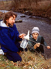
In one study, conducted from 1992 to 1994, the scientists tracked the movement of two common herbicides, atrazine and alachlor. Each March, they applied the herbicides to a cornfield bordered at its lowest end by a 150-foot grass and forest buffer. After the experiment's first year, they clearcut one block of the field's forest buffer, thinned another, and left intact a third block of mature forest closest to the stream.
The scientists measured the concentration of the chemicals in each block throughout the year. Their results showed virtually equal concentrations among the three block treatments.
|
|

"This showed us that both the riparian forest buffer and the grass filter were effective at removing the herbicides from surface runoff during storms and from shallow groundwater," says Lowrance.
Compared to herbicide concentrations of 34 parts per billion (ppb) at the field's edge, the scientists detected the chemicals at concentrations of only 1 ppb or less near the stream.
The findings suggest that portions of riparian forest can be harvested for timber without compromising the buffer's integrity. Selective cutting can also promote regrowth.
A High-Tech Component
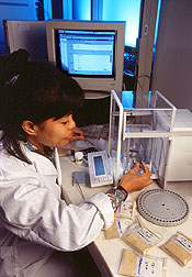
Not all of the Tifton research takes place along streams, creeks, and other waterways of the Little River Watershed. Now, scientists can also run computer simulations from their lab, using software they developed called REMM—short for Riparian Ecosystem Management Model.
With this software, they can simulate the movement of water, nutrients, sediment, and carbon in runoff or groundwater passing through a buffer. They can also test the effectiveness of a particular buffer design against different soil types, land elevations, or fertilization practices.
REMM "gives you a tool for predicting what's most likely to happen, which is better than a seat-of-the pants guess as to how wide a buffer should be," says one of the model's developers, ARS agricultural engineer Randy Williams, who is based at Tifton.
His colleagues, ARS soil scientist Robert K. Hubbard and university animal scientist G. Larry Newton, will put REMM to work this spring when they conduct a pilot study at a commercial hog farm in Tift County. Their study calls for applying a liquid form of hog manure, called effluent, directly to a grass and pine forest buffer on the farmer's property. Effluent provides farmers with a cheap source of fertilizer for crops.
"But it's more difficult to control nutrients in the manure than it is in commercial fertilizer," notes Lowrance.
Study results could show whether surplus manure can be used to fertilize the buffer's trees and grasses for harvest, without allowing nutrients to wash into nearby waterways.
Safeguarding Oregon's Fisheries
While Lowrance's research has focused on riparian wetland buffers in well-drained watersheds of the southeastern United States, little work has been done to determine how effectively the buffers work on poorly drained soils in the West.
|
|
To help answer this question, plant pathologist Stephen M. Griffith and colleagues at Corvallis, Oregon, have been conducting studies for the last several years on poorly drained soils in western Oregon. In 1995, they began monitoring nitrogen movement in groundwater from grass seed fields through a riparian zone bordering Lake Creek in the southern Willamette Valley.
About half of all the cool-season forage and turf grass seed in the world is grown in the Pacific Northwest. The reason: The poorly drained soils won't support traditional crops. To grow ryegrass and other seeds, however, farmers usually have to add from 125 to 210 pounds of nitrogen per acre per year—creating potential for nitrogen runoff in surface and groundwater, Griffith says.
"There is a lot of concern about ground and stream water quality in the Pacific Northwest, with respect to salmon and trout and safe drinking water," Griffith says. "Little is known of how nonpoint-source water pollution is related to agricultural practices."
So in 1995, the scientists enlisted the help of local grower Don Wirth, who planted perennial ryegrass on waterlogged clay soils near Lake Creek.
The ryegrass was fertilized in the fall of 1995 and again in late winter 1996. A 100-foot-wide riparian zone of three grasses—tall fescue, meadow foxtail, and velvetgrass—buffered the ryegrass field from the creek. The riparian zone had not been cultivated since 1975.
To measure waterflow beneath the soil surface, the researchers installed 18 wells, ranging about 3 to 5 feet deep, in three lines from the creek through the riparian zone and up to the edge of the cultivated ryegrass field. Oregon State University and EPA scientists also participated in the experiment. The group collected water samples every 14 days from September 1995 to April 1996. During that time, 36 inches of rain fell—just under the 30-year average of 37 inches.
The scientists found that the ryegrass crop used most of the total nitrogen fertilizer applied. The riparian zone helped use up the rest of the nitrogen as groundwater carried it from the ryegrass field toward the creek.
"This study shows that established riparian buffers can really help soak up excess nitrogen—even in poorly drained soils," Griffith says.
Studies like this show that nature's buffers and wetland areas do have an important role to play in today's agriculture. "But we'll never want to give people the impression that buffers are substitutes for sound agricultural practices," cautions Lowrance.
"In order to reduce water quality problems, we're going to have to do everything together," he says. "That means using buffers in concert with practices like integrated pest management, nutrient management, and no-till." — By Jan Suszkiw, Agricultural Research Service Information Staff, 6303 Ivy Lane, Greenbelt, Maryland 20770, phone (301) 344-2173.
Jill Lee, Dawn Lyons-Johnson, and Sean Adams of ARS contributed to this story.
Richard Lowrance and Robert K. Hubbard are at the USDA-ARS Southeast Watershed Research Laboratory, P.O. Box 946, Tifton, GA 31793; phone (912) 386-3462, fax (912) 386-7215.
Stephen M. Griffith is with the USDA-ARS National Forage Seed Production Research Center, 3450 SW Campus Way, Corvallis, OR 97331-7102; phone (541) 750-8742, fax (541) 750-8750.
Ron R. Schnabel is at the USDA-ARS Pasture Systems and Watershed Management Research Laboratory, Curtin Rd., University Park, PA 16802-3702; phone (814) 863-0939, fax (814) 863-0935.
Seth M. Dabney is at the USDA-ARS National Sedimentation Laboratory, Upland Erosion Processes Research Unit, 598 McElroy Dr., Oxford, MS 38655; phone (601) 232-2975, fax (601) 232-2915.
"Natural Environmental Protection Agents" was published in the February 1998 issue of Agricultural Research magazine. Click here to see this issue's table of contents.