In the Western United States
Using Technology To Save Water
With climate change expected to raise temperatures worldwide and make rainfall patterns harder to predict, pressure is mounting on farmers—who use up to 60 percent of the world’s fresh water—to cut back on water use. Nowhere is the U.S. water supply a more severe problem than in the Southwest, where droughts are common, reservoirs are closely monitored, and population growth is increasing demand.
ARS scientists in the Southwest are developing tools aimed at saving every possible drop with the help of satellite data, computer models, remote sensing, and other technologies. At the Arid-Land Agricultural Research Center in Maricopa, Arizona, Doug Hunsaker is developing a sensor system that can determine the water needs of small clusters of crops. And at the Jornada Experimental Range in Las Cruces, New Mexico, Al Rango is beefing up computer models and the network of sensors scattered throughout the Rocky Mountains that help forecast runoff into the Rio Grande, a crucial water source for farmers in Colorado, New Mexico, Texas, and Mexico.
Impact of Altered Snowmelt
The Rio Grande gets more than half of its water from snow melting off the Rockies in southern Colorado and northern New Mexico, a region where population growth is straining water supplies. Climate change is expected to diminish those snowpacks and alter when water flows from them into rivers, says Rango, a hydrologist.
|
|
Snow starts melting in the New Mexico mountains in late March and continues until late August. But climate change could disrupt that cycle. Temperatures in New Mexico have increased about 2˚C in summer and about 1˚C in winter over the past 10 or 20 years. That rise is expected to continue, producing earlier snowmelt and altering when water becomes available for crops grown in the Rio Grande basin, such as cotton, onions, chilies, and pecans, Rango says.
With climate change expected to alter snowmelt patterns, researchers need better information. Rango is a principal investigator for part of a 5-year National Science Foundation project that will help states collect better data on water supplies and help scientists better understand the effects of climate change on water supplies in the Southwest. Research is also being conducted by New Mexico State University, New Mexico Tech in Socorro, and the University of New Mexico in Albuquerque as part of the project.
|
|
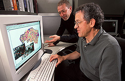
Rango and his colleagues have spent 30 years predicting snowmelt runoff levels with a computer model he developed in the late 1970s and has been upgrading ever since. His Snowmelt Runoff Model (SRM) uses climate-change algorithms, imagery of snowpacks from National Aeronautics and Space Administration satellites, and data from ground-based SNOTEL sensors in 11 western states to measure water levels. Information is transmitted to relay stations and posted by USDA’s Natural Resources Conservation Service (NRCS) online at
www.id.nrcs.usda.gov/snow/siteinfo/
typical_snotel.html.
Rango and his team will install 5 new gauges in the NRCS SNOTEL sensor network and upgrade 12 others, all in New Mexico, to improve runoff forecasts from snowpack. Rango’s research should help farmers decide which crops to plant and when to plant them. It will also help public officials decide how reservoirs should be operated, whether reservoir water should be stored or released, how much water should be used to generate electrical power, how flood-control measures can be implemented, and how much water should be reserved to save endangered species.
“Change in timing and quantity of runoff is something water-management agencies need to know. They don’t know what the effects on the water resources will be, and they need to know because water-management policies may have to change,” Rango says.
|
|
Tracking Water on Small Parcels
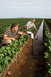
Traditionally, farmers irrigate by the calendar, but that can be wasteful—at times giving crops more water than they need. But Doug Hunsaker is using an assortment of remote-sensing technologies—sensors mounted on tractors or planted in the soil, along with an unmanned aerial vehicle and an occasional helicopter flight—to find ways of conserving water by estimating crop needs at specific sections within fields, rather than assuming those needs are the same in all sections of the field.
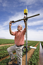
Hunsaker is testing a tractor-mounted visible and near-infrared sensor on small fields of cotton and wheat. The sensors, initially designed to detect nitrogen levels in soils, use red and near-infrared signals to estimate evapotranspiration—the amount of water transpired from a plant plus that evaporated from the soil. The sensors take readings as the tractor goes up and down the field during cultivation. They look and work like small cameras and are equipped with a global positioning system so they can give a precise reading of the location where the data was collected.
|
|
In Hunsaker’s system, data on soil moisture levels and water use by plants—collected from the tractor-mounted and ground-based sensors—would ultimately be tied into data beamed from satellites.
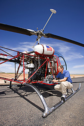
Hunsaker is also using remote-sensing data collected from an unmanned aircraft—on loan from the University of Arizona—that provides additional information on crop water use as it flies over a field. Helicopter flights, made once every 2 weeks as part of Hunsaker’s fieldwork, also provide complete remote-sensing images of the entire field. Data collected by the helicopter flights is a proxy for information that will one day be collected by satellites.
“As technology improves, satellites will be able to do what we now do with helicopters so that farmers will be using satellite imagery to determine water needs,” Hunsaker says. He has used the technology to study the water needs of camelina and lesquerella, two oilseed crops, but has focused mostly on small fields of cotton and wheat. He is currently testing the technology’s effectiveness at determining actual soil moisture levels and growth rates in a 12-acre cotton field, divided into 16 plots, and he plans tests in a wheat field of comparable size in 2010.
Farmers are already using remote-sensing technology to monitor crops and field conditions, but the goal is a new system capable of collecting data that farmers can use to determine daily water needs of smaller field sections. Ideally, farmers could identify areas with low or high water needs and, using either a drip or a sprinkler system, adjust irrigation levels based on the data.
Hunsaker compares the system to keeping a checkbook of each plant’s water needs. “There’s a reservoir of water in the soil. Each day it’s depleted by the plant, and we’re keeping track of that. Once the water amount reaches a certain threshold, we know it’s time to water, and we know how much it needs. We’re able to monitor with a kind of a ‘checkbook’ approach,” he says.—By Dennis O'Brien, Agricultural Research Service Information Staff.
The research is part of Pasture, Forage, and Range Land Systems (#215) and Water Availability and Watershed Management (#211), two ARS programs described on the World Wide Web at www.nps.ars.usda.gov.
To reach scientists featured in this article, contact Dennis O’Brien, USDA-ARS Information Staff, 5601 Sunnyside Ave., Beltsville, MD 20705-5129; phone (301) 504-1624, fax (301) 504-1486.
United States and Mexico Team Up on Water Issues
An increasing demand for water, the drying effects of climate change, and the prospects of declining aquifers have prompted an international effort to research and manage two key supplies of water for irrigation—the Ogallala Aquifer in the U.S. Southwest and the Calera Aquifer in Mexico.
Both are in agricultural areas with little rainfall, limited recharge, and unsustainable demands from development and agriculture. Like the Ogallala in the booming Southwest, the Calera Aquifer in Mexico’s central northern state of Zacatecas serves an area seeing expansive urban, suburban, and residential development, as well as industrial growth. Zacatecas, for instance, is home to a brewery that makes popular Mexican beers.
A team of U.S. and Mexican scientists will study climate change scenarios that may be encountered in both regions over the next 50 years. The goal is to create a multi-institution research team to plan for sustainable development and find ways to use the aquifers to support agriculture and industry and meet drinking-water needs.
The program builds on efforts that began in 2003 when Congress authorized the Ogallala Aquifer Region program to develop strategies to extend that aquifer’s life. Scientists from the Agricultural Research Service’s Great Plains Agroclimate and Natural Resources Unit, in El Reno, Oklahoma, began focusing on the interactive effects of climate on water-management options. Texas AgriLife Research and the University of Georgia at Athens have also been key players.
The joint international effort began in 2007 with funds for a workshop in Zacatecas from the ARS Office of International Research Programs and the Mexican government. The U.S. Agency for International Development and USDA’s Foreign Agricultural Service also committed funding. Two key areas where work will focus are:
• A cooperative agreement between ARS scientists and university partners for climate analysis, working closely with Calera Basin stakeholders.
• Computer models of climate-management scenarios linked to satellite data. The scenarios will be evaluated using the ARS Soil and Water Assessment Tool model, which deals mainly with surface-water movement and is linked with the U.S. Geological Survey’s Modular Finite-Difference Flow model for groundwater flow predictions.
“We will all benefit as we face the growing challenge of how to meet the world demand for food, most of which will have to come from irrigated lands,” says Prasanna Gowda, an ARS agricultural engineer in Bushland, Texas.—By Don Comis, Agricultural Research Service Information Staff.
"In the Western United States: Using Technology To Save Water" was published in the September 2009 issue of Agricultural Research magazine.


