United States Department of Agriculture
AgResearch Magazine


Chesapeake Bay Cleanup Revs Up!
|
|
President Barack Obama’s May 12, 2009, Executive Order on Chesapeake Bay Protection and Restoration directed federal agencies to clean up the bay and to promote reliance on adaptive management to increase environmental benefits.
This management approach means using ecosystem monitoring, with rapid feedback, for improved decisionmaking in managing land to reduce pollution of the bay.
The Agricultural Research Service’s merging of remote-sensing, field-sampling, and farm-program records to judge the effectiveness of winter cover crops in controlling nitrogen losses from fields fits the bill in several ways. It is the type of use of advanced monitoring tools the order calls for, with many rapid feedback loops to allow adjustments each fall, when winter cover crops are planted in the bay area. Winter cover crops are an important practice for capturing nitrogen left over from fall-harvested crops before it can pollute the bay.
Promoting Successful Cover Crop Solutions
In a 4-year study using this combination of remote-sensing tools, Greg McCarty, a soil scientist at the ARS Hydrology and Remote Sensing Laboratory (HRSL) in Beltsville, Maryland, and Dean Hively, now a visiting physical scientist from the U.S. Geological Survey Eastern Geographic Science Center, showed that, of the predominant winter cover crop species planted in Maryland—rye, barley, and wheat—wheat is by far the least efficient at taking up nitrogen because of its slow fall growth. Yet 60 percent of the land planted to cover crops is in winter wheat. The State of Maryland pays farmers to plant cover crops, with a premium for early-planted and nonwheat crops.
McCarty and Hively also used the tools to calculate that it costs taxpayers about $9 for each pound of nitrogen sequestered by winter wheat, while it only costs $2.50 per pound of nitrogen for rye and $3.50 for barley. These calculations will be made each year on a field-by-field basis, and will also include analysis of planting techniques and time of planting.
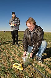
Every year, the ARS scientists look at cost-share program enrollment records to locate all cover crop fields in their Eastern Shore study area. In late December, the scientists acquire satellite imagery of the fields to measure fall cover crop growth and again in March to measure spring growth. Simultaneous with satellite imagery acquisition, the scientists hand-sample 30 cover crop fields to calibrate the satellite-derived measurements.
|
|
Pilot Project for Cover Crop Monitoring
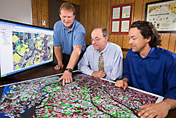
The scientists are developing GIS (geographic information system) software to automate cover crop monitoring and management reporting. A prototype package goes operational this year with a pilot project in Talbot County, Maryland. Every participating farmer will receive a field-by-field report of cover crop performance, as well as a county summary report. Soil conservation district offices will then be able to evaluate underperforming fields to strategize for improved implementation in the coming year. With success, the project will be scaled up to each of Maryland’s 24 soil conservation districts.
The scientists are also developing software to summarize the data by county and watershed and produce reports to the Maryland Department of Agriculture (MDA). This is part of the feedback system, leading to potential adjustments in federal and state conservation program implementation strategies.
“This represents a shift from modeling to actual measurement of conservation practice performance, with tabular summaries of cover crop nitrogen uptake and associated costs made available at county and watershed levels, in a timely fashion,” McCarty says.
In the past, scientists and managers had to rely on cover crop performance data derived from plot-scale research. The new technique allows performance monitoring on a watershed scale, with analysis pertaining to all farms participating in the cost-share program for winter cover crops.
Farm Records Give Realistic View
“Another unique feature of this program is that, unlike most remote-sensing specialists and computer modelers, we have access to on-the-ground agronomic management data on a field-by-field basis,” says Hively. “For example, the farm cost-share records tell us what variety of crop was planted, on what date, using what method, following what summer crop. This information can be combined with remote sensing to evaluate the outcomes of various management strategies used by farmers, while maintaining farm privacy.”
The interagency research team, led by McCarty and Hively, works closely with the MDA Office of Resource Conservation Operations, which manages the cover crop cost-share program.
Says Royden Powell, MDA assistant secretary, “Cover crops are our top priority for controlling nitrogen and phosphorus flows to the bay. The remote-sensing technology to identify crops and their growth progress from space has been developed and perfected over the past 5 years. Combining remote sensing with farm records and field sampling gives us more exact inputs for the Chesapeake Bay model.”
The cover crop project is an outcome of the Choptank River Conservation Effects Assessment Project. (See “ARS Chesapeake Bay Research Intensifies” in this issue.)
In addition to ARS funds, the cover crop project is also supported by $1.3 million in Chesapeake Bay program watershed grants administered by the National Fish and Wildlife Foundation. These funds are used for research and to increase cost-share funding, accounting for the planting and evaluation of 13,000 acres of cover crops.
“Business as usual” meant judging bay cleanup progress through water-quality measurements of the bay and its tributaries, such as the Choptank River. But water-quality measurements often reflect past management, because it can take 30 years or more for nitrogen and other pollutants to filter through the soil to groundwater and resurface in a stream on the way to a river and the bay.
Faster Feedback
“The ARS program provides rapid—rather than decades-old—feedback so that the annual effects of practices such as crop choice, planting technique, and timing can be seen and corrected the next season, if needed,” Hively says.
Participating scientists also include HRSL soil scientist Ali Sadeghi, USDA Forest Service ecologist Megan Lang, and chemist Laura McConnell, from the ARS Environmental Management and Byproduct Utilization Laboratory in Beltsville.
Maryland doubled its budget for its cover crop cost-share program to $18 million in 2008-2009 and budgeted $12 million for 2009-2010. This year, farmers enrolled 330,500 acres in the program.
But how much nitrogen loss do these cover crops prevent? The answer will be provided annually on a local basis using this project’s innovative combination of remote sensing, farm-management records, and field sampling.—By Don Comis, Agricultural Research Service Information Staff.
This research is part of Water Availability and Watershed Management (#211), an ARS national program described at www.nps.ars.usda.gov.
To reach scientists mentioned in this article, contact Don Comis, USDA-ARS Information Staff, 5601 Sunnyside Ave., Beltsville, MD 20705-5129; (301) 504-1625.
"Chesapeake Bay Cleanup Revs Up!" was published in the August 2010 issue of Agricultural Research magazine.