United States Department of Agriculture
AgResearch Magazine


A River Runs Through It: The Jornada Experimental Range Battles Desertification |
|
 Technician Dara Parker and John Anderson, manager of the Long-Term Ecological Research (LTER) Network site, reset weather recording equipment used in Jornada Range studies that focus on global climate change, desert ecology, rangeland management, and the worldwide threat of desertification. (K11295-1) |
The third longest river in North America, the Rio Grande, runs through the middle of North America's largest desert. Located mostly in Mexico, the Chihuahuan Desert intrudes quite a bit into New Mexico, and somewhat into Arizona and Texas as well. The river brings water—largely from snow melted in the mountains of Colorado—to farmers and urban desert dwellers through much of the Southwest. The Rio Grande also runs right through Las Cruces, New Mexico, where the ARS Jornada Experimental Range has a 29,000-square-foot laboratory-and-office facility, barely 2 years old, on the campus of New Mexico State University (NMSU). The Jornada Experimental Range comprises 193,000 acres in the middle of New Mexico's share of the desert. It is surrounded by national forests, like the Gila, nature preserves, and other public lands and federal complexes, including the White Sands Missile Range. Livestock graze parts of the range, but they are outnumbered by wildlife, such as coyotes, mountain lions, javelinas, antelope, desert bighorn sheep, kangaroo rats, black-tailed jackrabbits, and desert cottontails. |
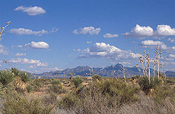 Grassland-shrub savanna characteristic of the northern Chihuahuan Desert on the 193,000-acre Jornada Experimental Range. (K11299-1) |
The Jornada is an important site for research on the health of rangeland in this desert—and of other desert rangelands in the western United States. With about a century of data under its belt, the research center has become one of the premier rangeland institutions in the world. Its scientists—working cooperatively with many other institutions, agencies, and universities, including counterparts in Mexico—have helped to improve application of ecological concepts to range management and develop new technologies for conserving deserts in many parts of the world. This year, they will publish research results in a book that will make a significant contribution to developing standards for monitoring rangeland health here and abroad. The new facility at NMSU houses most of Jornada's 80-plus staff members, including 11 permanent scientists and a total federal staff of 37. The U.S. Department of Agriculture (USDA) provides base funding of about $4 million a year. Additional funding through grants and contracts of over $1 million a year supports 45 more full-time and part-time staff, mainly through a cooperative agreement with NMSU. |
 Postdoctoral research associate Enrique Gomez-Landesa (background) and hydrologist Al Rango evaluate output from their predictive models of water runoff into the Upper Rio Grande Basin. (K11284-1) |
A Laboratory for the World The Jornada Experimental Range lies in a broad valley filled with alluvial materials, between mountain ranges of the Basin and Range Province. This topography extends westward through Arizona's Sonoran Desert and into the Mohave Desert of southern Nevada and California. USDA acquired the Jornada in 1912, but there is some experimental data on the area dating back to 1858. ARS began operating the site in 1954, soon after the agency was formed. The Jornada is home to the 960-acre, topographically and biologically diverse Chihuahuan Desert Nature Park. The National Science Foundation (NSF) helps fund the nonprofit organization that runs the park and works with Jornada staff to bring science education to 12,000 students and 700 teachers each year. |
 At the Jornada Range, technicians Justin Van Zee and Elaine Kneller evaluate plant responses to experimental treatments. (K11292-1) |
The Jornada is also one of 24 sites—22 in North America and 2 in Antarctica—that are part of the NSF Long-Term Ecological Research (LTER) Network, which supplies a portion of the extra $1 million a year in funding. This network is a collaborative effort involving more than 1,100 scientists and students investigating a diverse array of ecosystems. At the Jornada, the network includes scientists from USDA's Natural Resources Conservation Service (NRCS) as well as from NMSU and universities across the United States and Great Britain. The LTER Network offers the broader environmental biology research community, including students and foreign scientists, the opportunity to cooperatively use these sites and long-term data. At the Jornada, the focus is on global climate change, desert ecology, rangeland management, and the worldwide threat of desertification. "Our ARS national program in rangeland melds well with LTER goals. Our collaborative studies in this program can be used to infer causes and consequences of desertification worldwide," says Kris Havstad, research leader at the Jornada. "Desertification is a major threat to dry areas around the world and is characterized by accelerated loss of the soil's protective vegetative cover," Havstad says. "When vegetation degrades, the resulting erosion by wind and water removes both soil and nutrients in soil that sustain life. There are many causes." |
 Postdoctoral research associate Mary Lucero and animal scientist Rick Estell evaluate plant-extract data from cattle diets. (K9101-20) |
LTER research concentrates on the Jornada's five major habitat types of the northern Chihuahuan Desert: black grama grassland, creosotebrush shrub, mesquite dunes, tarbrush shrublands, and playas, low-lying, grassy, infrequently flooded areas. The climate is characterized by abundant sunshine, wide daily temperature ranges, low humidity, and rainfall averaging only 9 inches a year. Snow is rare, but it's effective in wetting the soil because less evaporation occurs in the cold months. Looking Back To Predict Future Changes ARS ecologist Debra Peters came to the Jornada in 1998 and is the lead investigator for the Jornada Basin LTER team. She developed the ECOTONE computer model, which enables Jornada researchers to use many years of collected data to predict future changes on these landscapes. |
 Chihuahuan Desert Nature Park director Stephanie Bestelmeyer and Jornada station superintendent Eddie Garcia work with elementary school children on a field trip at the Jornada Range. (K11287-1) |
"One major threat to rangeland here is brush overtaking the black grama grassland, so we're very interested in knowing what conditions cause it," says Peters. "We named the model ECOTONE because that's the technical term for the transition area where two different life forms meet, such as grasses and shrubs. This model can predict where a grass area is likely to be overtaken by brush." So far, brush is winning, here and on many other continents, and it wins by leaps and bounds after years of drought, such as the one the area has undergone the past 5 years. ARS hydrologist Al Rango, an expert in remote sensing, spotted this trend by examining the Jornada's long history of data, including USDA aerial photography that began in the 1930s. He computed the speed of brush invasion and found that it picked up after severe droughts—especially the intense one in the 1950s. He sees the same thing today—a result of the current drought. Shrubs seem to outcompete grass in dry times. |
 Animal scientist Alfredo Gonzalez moves cattle as part of studies examining livestock grazing behaviors in desert landscapes. (K11280-1) |
Rango's main task these days is predicting how much water the Rio Grande will deliver to the desert, particularly to farmers who use the river to irrigate. Farmers around the Jornada grow mainly chili peppers, cotton, and pecans. Farther north, farmers use older, smaller irrigation systems to grow tomatoes and other high-value crops. Rango works with NRCS and the Bureau of Reclamation to research ways to predict the Rio Grande's streamflow. He has been predicting daily flow of the river at Del Norte, Colorado, for the past 3 years. He usually does forecasts for April through September, to cover the growing season. He checks the predictions with actual streamflow measured daily at Del Norte. Rango does these predictions using the Snowmelt Runoff Model (SRM), which he developed in the 1970s. Ironically, Rango first tested the SRM on the Rio Grande in the late 1970s while stationed at ARS's Beltsville (Maryland) Agricultural Research Center. The runoff model is used together with sensors positioned throughout the West to measure snowpack. Once streamflow predictions become operational, farmers will use them to decide which and how many crops to plant each year. They will also be used by NRCS, the U.S. Army Corps of Engineers, state engineers' offices, and others in managing these water resources. In 2001, when the National Aeronautics and Space Administration launched the Terra satellite with the new MODIS (Moderate Resolution Imaging Spectroradiometer) sensor, Rango and colleagues began using this imagery of snow-covered parts of the Chihuahuan Desert and mountain snowpacks in Colorado and New Mexico. Later, NASA launched a complementary satellite, Aqua, which also supplies data to Rango. The MODIS sensors give a higher resolution than satellite imagery he had been using. Rango also contributes his remote-sensing expertise to other areas of Jornada research, including the monitoring of rangeland health and controlling of livestock grazing. Monitoring Rangeland Now ARS soil scientist Jeff Herrick and colleagues led the effort to develop an improved rangeland-monitoring manual for field use. It contains instructions for various soil and vegetation measurements and forms for ranchers and land managers to record data. "It provides a way to gather data needed to support rangeland assessments done with the guidelines that were first issued in 1999," Herrick says. Herrick co-authored those earlier assessment guidelines along with representatives of the U.S. Geological Survey, NRCS, and the Bureau of Land Management (BLM). These are now in use widely in the United States, and the Mexican government has translated them into Spanish. "This is one of the biggest impacts we have had," he says. Herrick is working with ARS ecologist Brandon Bestelmeyer, who is doing ecological descriptions of Southwestern rangelands based on research at the Jornada. Together they are integrating monitoring and assessment tools with the ecological models Bestelmeyer works with. They are collaborating with the U.S. Department of Defense, NRCS, BLM, and the National Park Service. The models Bestelmeyer works on are called "state and transition" models because they predict how broad areas of land might change under various management practices. So far, he has created or contributed to models that will work for much of New Mexico, Arizona, Utah, and Texas. They can help everyone from ranchers to government personnel in interpreting data on their land to make land-management decisions. Bestelmeyer is working with Peters and ARS range ecologist Sandy Tartowksi to describe how ecological drivers at different scales are changing vegetation. Their data feed into both ECOTONE and the state and transition models. Bestelmeyer says, "Historical data shows us that vegetation reaches a threshold point, a critical stage beyond which the change is irreversible. Here, that's usually grassland being replaced by shrubs. Different pressures, such as overgrazing or drought, can push land over the threshold. We want to predict when that threshold will be reached, so we can avoid it." Virtual Cattle Herding Animal scientist Dean M. Anderson has a vision of how to reduce grazing pressure by fencing sheep, cows, and other animals with Directional Virtual Fencing (DVF™), an invisible electronic fence similar to that sometimes used to control dogs. Anderson patented the concept in collaboration with Craig S. Hale of Future Segue, a private electronics firm in Las Cruces. "This tool combines electronic technology with animal behavior and knowledge of animal and plant biology to control livestock movement in a humane way," Anderson says. With it, cows would cross their large desert pastures, guided by Global Positioning System technology, to locations where forage is available and suitable for grazing. They would keep returning to a watering hole where they would get "marching orders" from satellites. Computer nodes at the watering hole would download the cows' meandering data and send it back for analysis of grazing patterns. DVF data is stored in an electronics package similar in size to a deck of playing cards. The current version of the device is worn on a neck collar that sends cues to ear tags to steer the cows to water or fresh grass. When the cows are first learning their boundaries, they get an audio cue or a mild electric shock similar to that used on dogs. Anderson has proven the concept works by testing prototypes on three cows and using them to move a small herd around. By the end of 2004, he expects to have many more prototypes built to conduct larger-scale tests."We're right on the verge of commercializing this device," he says. Rango is helping Anderson find ways to eventually link with satellites that would locate desirable grazing areas for livestock. The End of Range Wars Tartowski, who is working to develop new remediation technologies, has high hopes for Anderson's research. She knows from the ranchers and land managers she works with how much they would like to do away with traditional fences. "It's a major cost to build and maintain fences," she says. "And they're not always placed in the areas that make the most sense in terms of rainfall patterns or animal management." The main thing that impresses Tartowski about DVF technology is that it changes the perception of livestock from being a land problem to a land-improvement tool that can help shape the landscape in a desirable way. Virtual fencing—like much of the Jornada research—can help slow desertification or even stop it in some cases, because it promises an economical way to keep cattle properly distributed across the range. Research at the Jornada is all about judiciously nudging natural ecosystem processes to improve land health while supporting sustainable human use. More than a century's experience with a landscape that still bears the scars of natural assaults on vegetation and misuse from the days of the Old West provides an ideal laboratory for meeting these needs. Furthermore, tools like the ECOTONE model allow scientists to make better use of this historical data to forecast future dynamics. The Jornada scientists are helping build a database for rangeland management that has significance for the one-third of the Earth's land mass that is desert—an area that is increasing all the time.—By Don Comis, Agricultural Research Service Information Staff. This research is part of Rangeland, Pasture, and Forages, an ARS National Program (#205) described on the World Wide Web at www.nps.ars.usda.gov. To reach scientists mentioned in this article, contact Don Comis, USDA-ARS Information Staff, 5601 Sunnyside Ave., Beltsville, MD 20705-5129; phone (301) 504-1625, fax (301) 504-1641. "A River Runs Through It: The Jornada Experimental Range Battles Desertification" was published in the July 2004 issue of Agricultural Research magazine.
|