United States Department of Agriculture
AgResearch Magazine


To Keep Rivers Within Bounds: A Channel Erosion Guide
|
|
|
|
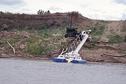
In the world of finance, bank failures tend to get press coverage. But there's another kind of bank failure that affects the American West: Missouri River bank failures in eastern Montana involve lost soil—not dollars—but still hurt farmers financially.
Just ask Boone Whitmer, who farms 3,000 acres of wheat and alfalfa near Wolf Point. Like most farmers bordering the Missouri River downstream from the Fort Peck dam, he places irrigation pumps along the banks to get water for his crops. But the shifting sand bed of the river can clog pumps with sediment and hit growers like him hard. “In the winter, you can have a working pump site, but by spring it's silted,” he says. “Replacing a pump site is bad news for anybody. It cost me $20,000.” Whitmer says many farmers along the Fort Peck reach also worry about losing farmland to streambank erosion. “It's not that huge amounts of land are being lost. But if you only own 200 acres and lose 10, that can be quite significant,” says John Remus, a hydraulic engineer with the Water Resource Branch of the U.S. Army Corps of Engineers in Omaha, Nebraska. “Bank failures happen when a river erodes its bed so deeply that the water level is too low and the upper banks are exposed,” says ARS geologist Andrew Simon. “It's the weight of the water against the river banks and the stability of the soils in the banks that hold them up.” Whitmer and other local farmers now have a new resource to help them prevent these problems, thanks to researchers at the USDA-ARS National Sedimentation Laboratory (NSL) in Oxford, Mississippi, and their scientific collaborators throughout the United States. This team of scientists and engineers has prepared a guide, “Channel Erosion Problems on the Missouri River, Montana, Between Fort Peck Dam and the North Dakota Border.” It is available on line at NSL's web site: http://msa.ars.usda.gov/ms/oxford/nsl/cwp_unit/Montana_Report.html. “It will help people and agencies manage the river corridor using scientific evaluation of the river and its relationship to the dam,” says Simon, who is with NSL and is the guide's senior author and editor. Simon used his knowledge of stream processes and streambank stability to locate the weakest and most susceptible banks, so Montana farmers can know where to make improvements along a certain reach of the river. “A river will transport sediment. If you take away the supply of sediment at one location, the river will find another source of it further down,” says Remus. “But that doesn't mean a mile of protected banks will cause erosion a mile downstream. It has to do with soil properties. We hope Simon's data will tell us where weak spots are and what effects might occur when we do stabilize an area.” Simon is also exploring how to reduce the stress on banks in winter during dam opening. The channel erosion guide also benefits from research done by NSL hydraulic engineer Doug Shields, Jr. He worked with soil scientist Lyle Steffen of USDA's Natural Resources Conservation Service (NRCS) in Lincoln, Nebraska, to document the average rate of river bank migration for the past several decades. “Before Fort Peck dam was built in the 1930s, the river channel moved across the floodplain about 6.6 meters, or about 22 feet, per year,” says Shields. “However, since large floods have been just about eliminated by the dam—and since most erosion occurs during floods—current averages of lateral movement have decreased to about 1.8 meters, or 5.9 feet, per year.” Ice Is Not Nice Simon's publication also reports research on ice effects, contributed by river ice engineering expert Robert Ettema. He is with the Institute of Hydraulic Research at the University of Iowa-Iowa City. “Ice is an important factor in the river's overall behavior,” says Ettema. “It seems to do something to the river. You see sediment accumulations and bars appear that can affect pump intake sites.” Scientists and engineers with ARS and NRCS are working with Ettema and the U.S. Army Corps of Engineers to understand what happens when the river ices over. The Corps' Cold Regions Research and Engineering Laboratory will play a role in this effort. Farmers are also critical partners in this research. Ettema says he is indebted to local producer Alan Pipal, who alerts him to changing conditions. “We want to study how ice forms, how thick it gets, and how it affects river flow, so we need before-and-after measurements,” says Ettema. The information on ice will also benefit Remus in his work with the Corps of Engineers. “When considering ways to stabilize banks, we need to know whether it's most important to measure soil strength, frost penetration, or depth to groundwater,” says Remus. “Measurements cost money, and we don't want to waste funds looking at factors that don't really matter.” Getting the Best Return Jim Suit, a state engineer with NRCS in Montana, will also use this channel erosion guide. “If tax dollars are going to be spent on bank stabilization and restoration and you have 10 candidate sites but money for only 5, you want to do the most with the money you have.” Knowing more about how the dam and river interact will help residents around Fort Peck share both the benefits and burdens. In 1994, Paul Johnson, then chief of NRCS, traveled to eastern Montana to help residents form the Lower Missouri River Coordinated Resource Management Group. The group includes representatives from six county conservation districts and the Sioux and Assiniboine tribes living on a reservation near the dam. They use the group to discuss how to use the river and protect its banks. It serves as a public forum, to be sure that everyone benefits from the Missouri River and that the cost of its protection is shared. “Cooperation is critical,” says Suit. “And having accurate information is one way to balance everyone's needs. Say somebody wants to move grain barges below Sioux City, Iowa—or say it's a really cold day and power consumption is up—the U.S. Army Corps of Engineers will get a request to release water from the dam to increase flow rates or to generate electricity. Everybody here wants healthy wildlife and bank stability, but they also want flood control and grain transport—and enough electricity for Monday night football.”—ByHank Becker and Jill Lee, both formerly with ARS. This research is part of Water Quality and Management, an ARS National Program (#201) described on the World Wide Web at http://www.nps.ars.usda.gov. Andrew Simon is in the USDA-ARS Channel and Watershed Process Research Unit, and Doug Shields, Jr., is in the Water Quality and Ecology Research Unit, National Sedimentation Laboratory, P.O. Box 1157, Oxford, MS 38655; phone (662) 232-2918 [Simon], (662) 232-2919 [Shields], fax (662) 232-2920. |
|
"To Keep Rivers Within Bounds: A Channel Erosion Guide" was published in the January 2002 issue of Agricultural Research magazine. |